
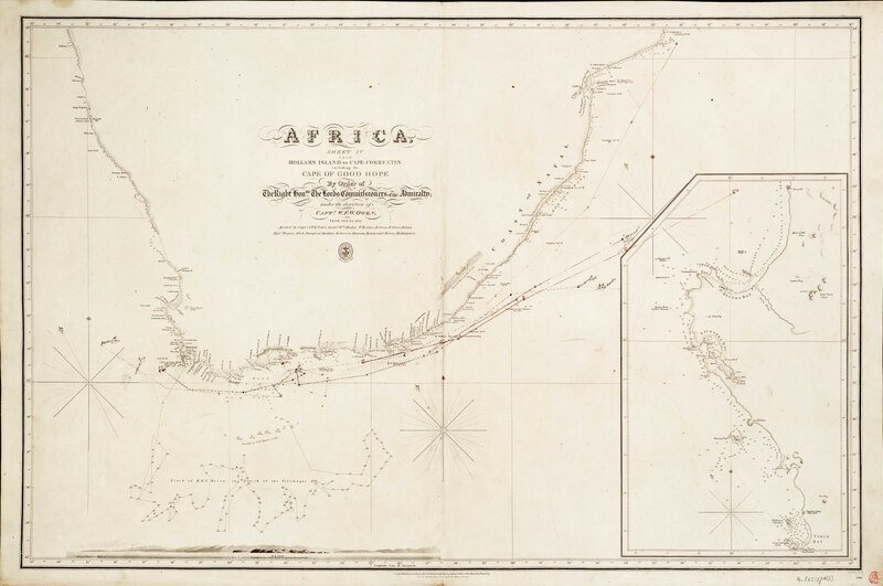
File:Admiralty Chart No 596 Africa, sheet IV from Hollams Island to Cape Correntes including the Cape of Good Hope - from 1822 to 1826 RMG F0115, Published 1827.tiff
Original file (7,305 × 4,842 pixels, file size: 101.2 MB, MIME type: image/tiff)
Captions
Captions
Summary
[edit]| Author |
Captain W. F. W. Owen; Hydrographic Office; J. & C. Walker |
| Description |
English: Africa, sheet IV from Hollams Island to Cape Correntes including the Cape of Good Hope... from 1822 to 1826Single sheet. Engr. Medium: Linen-backed. Scale: [ca. 1:1 000 000]. Cartographic Note: Graduated. Variation shown. Contents Note: Track of HMS Heron in search of the Telemaque 1821. Soundings by HMS Pandora on the Agulhas Bank, 1851, Inset: [Cape Descada to Cape Town] [ca. 1:400 000], View:[Danger Point and Dyer Island].
Ms ships tracks show the effects of currents near the Agulhas Bank. The Telemaque Rock was a shipping hazard hunted for unsuccessfully by Captain Hammer of HMS Heron (ship, 1812) in 1821. The rock was first reported by French Captain Geraud of the French Brigantine Telemaque. Hazard Rock in the South Atlantic |
| Date | 1827; 1851 |
| Dimensions | Printed area 62 x 94cm, on sheet 66 x 99cm. |
| Source/Photographer | http://collections.rmg.co.uk/collections/objects/540862 |
| Permission (Reusing this file) |
The original artefact or artwork has been assessed as public domain by age, and faithful reproductions of the two dimensional work are also public domain. No permission is required for reuse for any purpose. The text of this image record has been derived from the Royal Museums Greenwich catalogue and image metadata. Individual data and facts such as date, author and title are not copyrightable, but reuse of longer descriptive text from the catalogue may not be considered fair use. Reuse of the text must be attributed to the "National Maritime Museum, Greenwich, London" and a Creative Commons CC-BY-NC-SA-3.0 license may apply if not rewritten. Refer to Royal Museums Greenwich copyright. |
| Identifier | Acquisition Number: NA.52-27 Admiralty Chart Number: 596 GGCC: 252:2 id number: G252:2/4(2) |
| Collection | Charts and maps |
Licensing
[edit]|
This is a faithful photographic reproduction of a two-dimensional, public domain work of art. The work of art itself is in the public domain for the following reason:
The official position taken by the Wikimedia Foundation is that "faithful reproductions of two-dimensional public domain works of art are public domain".
This photographic reproduction is therefore also considered to be in the public domain in the United States. In other jurisdictions, re-use of this content may be restricted; see Reuse of PD-Art photographs for details. | ||||
File history
Click on a date/time to view the file as it appeared at that time.
| Date/Time | Thumbnail | Dimensions | User | Comment | |
|---|---|---|---|---|---|
| current | 10:35, 18 August 2017 |  | 7,305 × 4,842 (101.2 MB) | Fæ (talk | contribs) | Royal Museums Greenwich Charts and maps, http://collections.rmg.co.uk/collections/objects/540862 |
You cannot overwrite this file.
File usage on Commons
The following 2 pages use this file:
- File:Admiralty Chart No 596 Africa, sheet IV from Hollams Island to Cape Correntes including the Cape of Good Hope - from 1822 to 1826 RMG F0115, Published 1827.tiff
- File:Africa, sheet IV from Hollams Island to Cape Correntes including the Cape of Good Hope - from 1822 to 1826 RMG F0115.tiff (file redirect)
File usage on other wikis
The following other wikis use this file:
- Usage on en.wikipedia.org
Metadata
- Charts and maps of the Royal Museums Greenwich
- Admiralty Charts Region H: Southern Indian Ocean Arabian Sea Persian Gulf Red Sea Islands in the Southern Ocean
- Admiralty Charts Region G: Africa south and west Coasts Azores Canaries Cape Verde Islands
- 19th-century maps of South Africa
- Admiralty Charts 401-600
- Elizabeth Bay (Namibia)
- Maps of Orange River
- St Helena Bay
- Maps of the Cape of Good Hope
- L'Agulhas
- Maps of Port Elizabeth
- Maps of Maputo
- William Fitzwilliam Owen