Atlas of East Timor

From Wikimedia Commons, the free media repository
Jump to navigation Jump to search
Wikimedia Commons Atlas of the World

The Wikimedia Atlas of the World is an organized and commented collection of geographical, political and historical maps available at Wikimedia Commons.
Discussion • Update the atlas • Index of the Atlas • Atlas in categories • Other atlases on line
The introductions of the country, dependency and region entries are in the native languages and in English. The other introductions are in English.
 
Atlas-country
East Timor


Timór Lorosa'e
Timor-Leste

Tetum Timór Lorosa'e - Repúblika Demokrátika Timor Lorosa'e

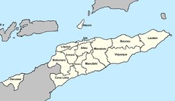
Repúblika Demokrátika Timor Lorosa'e ne'e hanesan nasaun ida nebe moris ikus liu iha mundo rai klaran, tur iha fatin sorin Timur iha Rain Timór, iha sorin ida hetan rai Timór nian rohan hanesan Oe-Kusi, iha fali lolon sorin nian kotuk mak Ataúru, nune'e mos iha rain ki'ik oan balu nebe tur iha lolon sorin Timur nian nebaa. Rai Timór iha fronteira ho rai seluk mesak ida deit, mak rai Indonézia nian sorin nebee tutan malu ho iha sorin loro-monu nebe fahe malu ho sorin loro-sa'e, iha mos rai sorin nebe tutan malu ho Oe-Kusi. Maibe iha mos fonteira iha tasi nebe ketak malu ho Austrália, Tasi Timór iha kanosan sorin. Dili mak sidade boot liuhotu no kota inan ba Timór.

Português Timor-Leste - República Democrática de Timor-Leste

A República Democrática de Timor-Leste é um dos países mais jovens do planeta Terra que ocupa a parte oriental da ilha de Timor, no extremo sudeste da Ásia, a ilha de Ataúro, a norte, e o ilhéu de Jaco, ao largo da ponta leste da ilha, para além do enclave de Oecusse, na costa norte da banda ocidental da ilha de Timor. As únicas fronteiras terrestres do país são com a Indonésia, a oeste da porção principal do território, e a leste, sul e oeste de Oecussi. Timor-Leste tem também fronteira marítima com a Austrália, no Mar de Timor, a sul. A cidade de Díli, a capital, localiza-se na costa norte.

Deutsch Osttimor - Demokratische Republik Osttimor

Die Demokratische Republik Timor-Leste ist ein Land in Südostasien, das aus dem Osten der Insel Timor, der Exklave Oecusse im Nordwesten Timors und den kleinen Inseln Arauro und Jaco besteht. Osttimor hat eine gemeinsame Landgrenze mit Indonesien, zu dem auch die benachbarten Inseln gehören, südlich liegt Australien. Osttimor hat eine Fläche von 14.954,44 km² und 1.066.409 Einwohner (Zensus 2010)

English East Timor - Democratic Republic of Timor-Leste

The Democratic Republic of Timor-Leste,[1] is a country in Southeast Asia comprising the eastern half of the island of Timor, the nearby islands of Atauro and Jaco, and Oecusse, an exclave on the northwestern side of the island, within ► Indonesian West Timor. The small country of 5,376 square miles (14,609 square kilometres) is located about 400 miles (640 km) northwest of Darwin, ► Australia.


Short name  East Timor
Official name Democratic Republic of Timor-Leste
Status Independent country since 1975, subject to Indonesian occupation in 1976, regained independence in 2002.
Location South East Asia
Capital Dili
Population 1,299,412 inhabitants
Area 14,918.72 square kilometres (5,760.15 sq mi)
Major languages Tetum, Portuguese (both official), 15 further national languages recognized by constitution
Major religions Roman Catholicism
More information East Timor, Geography of East Timor, History of East Timor and Politics of East Timor
More images East Timor - East Timor (Category).

General maps

East Timor at the globe
East Timor in Asia
East Timor in the Malay Archipelago
Map of East Timor
Map of East Timor
Map of Timor
Map of Timor
Map of Timor
Administrative map of East Timor
Municipalities of East Timor 2003–2015
Municipalities of East Timor 2015–2022
Municipalities of East Timor since 2022
Administrative posts of East Timor
Sucos of East Timor (Timor-Leste)
Cultural Regions of East Timor
Languages of East Timor
Catholic dioceses of East Timor
Coffee production in East Timor
Coconut production in East Timor
Maize production in East Timor
Cavasa production in East Timor
Rice production in East Timor
Important Bird Areas in East Timor
Freedom of speech in East Timor, 2008

Maps of divisions

This section holds maps of the administrative divisions.

Municipality of Aileu
Municipality of Ainaro
Administrative post of Ainaro
Administrative post of Hatu Builico
Administrative post of Hatu Udo
Administrative postt of Maubisse
Municipality of Baucau
Municipality of Baucau 2003–2015
Municipality of Baucau since 2015
Municipality of Bobonaro
Administrative post of Atabae
Administrative post of Balibo
Administrative post of Bobonaro
Administrative post of Cailaco
Administrative post of Lolotoe
Administrative post of Maliana
Municipality of Cova Lima
Administrative post of Fatululic
Administrative post of Fatumean
Administrative post of Fohorem
Administrative post of Maucatar
Administrative post of Suai
Administrative post of Tilomar
Administrative post of Zumalai
Municipality of Dili
Administrative post of Atauro
Administrative post of Cristo Rei
Administrative post of Dom Aleixo
Administrative post of Metinaro
Administrative post of Nain Feto
Administrative post of Vera Cruz
City of Dili
Municipality of Ermera
Municipality of Lautém
Municipality of Lautém 2003–2015
Municipality of Lautém since 2015
Municipality of Lautém
Administrative post of Iliomar
Administrative post of Lautém
Administrative post of Lospalos
Administrative post of Luro
Administrative post of Tutuala
Municipality of Liquiçá
Municipality of Manatuto 2003–2015
Municipality of Manatuto since 2015
Municipality of Manatuto
Municipality of Manufahi
Municipality of Oecusse
Administrative post of Nitibe
Administrative post of Oesilio
Administrative post of Pante Macassar
Administrative post of Passabe
Municipality of Viqueque
Municipality of Viqueque 2003–2015
Municipality of Viqueque since 2015
Municipality of Viqueque
Administrative post of Uatucarbau

History in maps

This section holds a short summary of the history[2], illustrated with maps.

Rebellions in Portuguese Timor 1860 to 1893
Rebellions in Portuguese Timor 1894 to 1910
Rebellion of Manufahi 1911 to 1912
Japanese invasion in Portuguese Timor 1942/43
Indonesian invasion in East Timor 1975 to 1979
Resistance sectors in East timor 1975 to 1999
Districts of East Timor (Borders before 2003)
Internal Displaced Persons 2006 in East Timor
Hot Spots of unrests in Dili 2006
Population displacement in Baucau and Viqueque 2007

Notes and references

General remarks:

  • The WIKIMEDIA COMMONS Atlas of the World is an organized and commented collection of geographical, political and historical maps available at Wikimedia Commons. The main page is therefore the portal to maps and cartography on Wikimedia. That page contains links to entries by country, continent and by topic as well as general notes and references.
  • Every entry has an introduction section in English. If other languages are native and/or official in an entity, introductions in other languages are added in separate sections. The text of the introduction(s) is based on the content of the Wikipedia encyclopedia. For sources of the introduction see therefore the Wikipedia entries linked to. The same goes for the texts in the history sections.
  • Historical maps are included in the continent, country and dependency entries.
  • The status of various entities is disputed. See the content for the entities concerned.
  • The maps of former countries that are more or less continued by a present-day country or had a territory included in only one or two countries are included in the atlas of the present-day country. For example the Ottoman Empire can be found in the Atlas of Turkey.
  1. This name is officially used in English too.
  2. The text of the summary of the history is mainly based on the text in Wikipedia.

Entries available in the atlas

General pages
World
Continents and oceans
Themes
Historical eras
States with wide recognition
States with limited recognition
Dependencies and other overseas territories
Country subdivisions
Belgium
China (mainland)
India
Pakistan
Spain
United Kingdom
United States
Other
Disputed subnational territories
Other regions
Cities
Former sovereign states
Former dependencies and overseas territories
Former disputed territories


References