
Weather Alert Day: Severe threat winding down
UPDATES:
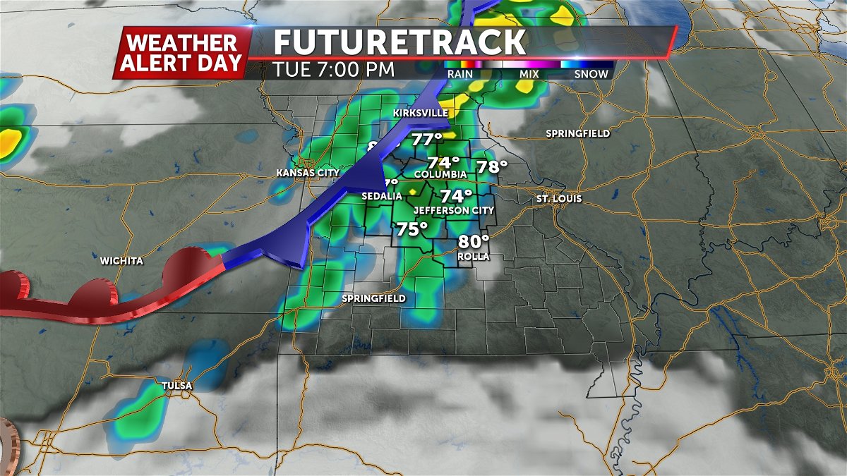
TUESDAY EVENING UPDATE:
A few severe storms continue to work east, mainly south of Highway 50. The severe threat is likely to exit Mid-Missouri by around 10:00 PM. Several counties have been removed from the Tornado Watch. Power outages and wind damage has been reported across several areas, including in the Warsaw and Eldon areas.

As of Tuesday at noon, the Storm Prediction Center highlights greater confidence in higher level severe threats further south into Mid-Missouri; now including areas north of HWY 24 in a level 4 of 5. This is an area where storms will have a better chance at producing impacts like 2 inch hail and strong (EF-2 or greater) tornadoes. Still, this is largely in line with thinking from yesterday, when we expected a better chance for these types of storms in the north.
We will raise our threat level for damaging winds and hail, given these will be more common outcomes, but keep our tornado risk where it is, given some limiting factors for most of mid-Missouri, but with the explanation that a strong (EF-2 or larger) tornado is entirely possible this evening.


A notable change in Futuretrack does highlight a slightly earlier arrival time, and a more southern position at arrival in our western counties. Additionally, this earlier trend correlates with an earlier exit, so confidence is growing that this will not be an all night event.
BLOG:
The ABC 17 Stormtrack Weather Team has issued a Weather Alert Day for Tuesday afternoon into the evening ahead of the potential for severe thunderstorms. Much of Mid-Missouri is in a level 3 out of 5 severe risk from the Storm Prediction Center, which means scattered severe thunderstorms are likely in the orange shaded region.

Mid-Missouri will be centered in the warm sector of a storm system that will feature low pressure to our north across northern Iowa/southern Minnesota. Temperatures rise to near 90 by late afternoon with dew points in the mid-upper 60s, providing ample fuel for storms to develop and move through the area by late afternoon into the evening ahead of a cold front.
Isolated storms could start popping up as early as about 3:00 p.m., and these singular storms will be capable of producing all severe hazards, including large hail., damaging winds, and tornadoes. The main overarching threat, however, will be for a line of damaging winds between 60-70 mph that develops after sunset along the cold front.
That line is more likely after about 7:00 p.m. through about midnight as the front works southeast overnight into Wednesday morning.

Make sure you have multiple ways to receive severe weather alerts. The ABC 17 Stormtrack Weather app is a great resource for warnings, and you can set notifications to alert you about lightning in the nearby vicinity.
