
This is a blog by the Amazon Mining Watch team, a Mozilla Technology Fund awardee.
___
When I hear the words gold rush, I can’t help but think of Levi’s and stage coaches. That’s the version I learned as a school kid. Now, as then, the reality is more bleak: shattered forests, toxic sludge, violence against people who have long made their homes in the forests with gold hidden among the roots.
Amazon Mining Watch is relaunching today as a true monitoring platform to track illegal open-pit gold mining in the Amazon rainforest. Automated, machine-learning models detect mining in satellite imagery, yearly across the Amazon basin and from now into the future. Data and code are available open-source.
Something — strongman politics and dire economic conditions, the high price of gold and access to international markets, dissident paramilitaries and cartels with drug money to launder and invest — has touched off new gold rushes around the Amazon rainforest. Some miners go in thinking of feeding their families. The sociopolitical dynamics are complex.
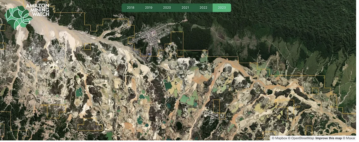
The mining is expanding terribly, every year from 2018 through 2023, almost doubling in area, measuring at 3.2 million acres last year. Let it be said, we make detections on sixty-acre parcels, so this number counts some strips of forest at the edges of the toxic mining sludge.
In 2023 our models detected mining in 7,163 distinct locations across the Amazon rainforest. Mean area: 450 acres. Max area: 35000 acres. The largest minefield stretches miles in all directions, dwarfing a nearby miners’ town, in Madre de Dios state in Peru.
At the same time, in some places, activism and government enforcement have begun to slow the razing of Earth. Amazon Mining Watch can play a role directing the spotlight. And for those people petitioning their local governments, demanding relief, with their own maps and first-person reports, the data can provide another measure of proof.
In 2019 the U.S. director of Survival International asked if we could help identify illegal gold mining operations in Yanomami indigenous territory. His contacts at Hutukara Yanomami Association were reporting a new influx of miners, akin to the gold rush of the 1980s that caused the deaths of so many Yanomami people through massacre, disease, and malnutrition. They were seeking international attention to pressure the Brazilian government to stop the miners invading their legally protected lands.
I looked in the ways that I knew as a satellite enviro-investigative journalist, starting with Google Earth. We asked about some features that turned out to be Yanomami villages. I had to report back to Daniel: I saw absolutely no signs of mining.
For weeks this gnawed at me. The Hutukara activists estimated 20,000 miners were active in the territory. The miners slash the rainforest, pump water through the underlying soils to release the minerals, and mix in mercury to clot with the gold. In Yanomami territory it’s strictly illegal, with no planning, no oversight. The miners churn verdant rainforest and its winding rivers into toxic mud. I had to be able to see destruction at that scale.
I reached for recent Sentinel-2 satellite imagery, captured frequently enough to work around the rainforest’s clouds. All of a sudden, a new picture of the territory unfolded before me. The banks of the important tributaries flowing out of northern Yanomami territory — the Uraricoera, the Mucajai, the Catrimani — were littered with bright yellow, brown, green, and turquoise splotches. I saw new mine sites and new airfields for trafficking, sometimes practically on top of Yanomami villages.
For me this marked the beginning of a journey of learning and reporting on the mining problem, linking with people working in the region, and eventually building the tools to automatically detect new mining activity across the Amazon basin.
Amazon Mining Watch v2.0
Amazon Mining Watch applies artificial intelligence modeling of Sentinel-2 satellite imagery to identify the scars of open-pit gold mining and to share data and reporting on the problem. When launched in 2022, the platform provided a snapshot view, state-of-the-mined-Amazon, from 2020.
This year, with support from the Mozilla Foundation, and critical code and model rewrites by co-creator and alum Caleb Kruse, we were able to realize the promise of Amazon Mining Watch as a true monitoring platform. The new release includes:
- Yearly assessments of mining activity in the Amazon basin from 2018–2023.
- Capacity to run new assessments on demand.
- High detection precision, estimated at 99.6% on a random sample of 2023 detections.
- Reproducible open-source code. Previously, we published the code, but it accessed imagery via a third-party proprietary platform. Now it requires only a Google Earth Engine user account, with free sign-up.
- A web front-end rebuilt from scratch.
- Yearly Sentinel-2 satellite image mosaics to underlay the yearly detections.
In a report released today, Amazon Conservation break down major findings from the new data. They identify the most impacted regions and study hot spots where mining has flared into protected lands. They estimate that half of the observable forest destruction from mining in the Amazon basin has happened in the last five years.
Putting data to work
Amazon Mining Watch is a collaboration involving many of us at Earth Genome; the Pulitzer Center Rainforest Investigations Network, who lead reporting; and Amazon Conservation, who build intra-government and community partnerships, particularly in Peru and Bolivia, to shape holistic policies toward curtailment of mining.
Amazon Conservation and MapBiomas uptake Amazon Mining Watch detections for their own monitoring efforts.
With Pulitzer Center and their wider network of journalists, news reports tackle the mining crisis from different angles. In the first use of automated detections, ArmandoInfo investigated dissident guerilla elements driving gold mining operations in Venezuela and resistance from indigenous communities along the Colombian border. The work was awarded the Global Shining Light Award from the Global Investigative Journalism Network.
Increasingly, we are getting requests for intelligence on mining in other parts of the world. We have an investigation running now in Southeast Asia. For this we are applying a new, more generalized AI tool, called Earth Index, which can detect mines and many other landscape features using pretrained open-source models. We are prototyping use cases and building the user interface to allow more investigators to draw insights out of satellite data, wherever they are working.
Hope and caution for the future
President Lula of Brazil promised a crackdown against illegal mining, and in January 2023, a series of military police raids took out a number of large mining encampments in Yanomami territory. Hutukara, with the support of Instituto Socioambiental, had worked for years to gather evidence to pressure the state government in Boa Vista for enforcement action. We can see that in 2023 the growth of mining in Yanomami territory did slow.
We hear also from our contact at Instituto Socioambiental that the cartels are resisting, with guns and shifting tactics. They are hiding encampments away from the minefields. The smaller operators are slipping away to other places, where the attention on mining is not so intense. On our scans, we see tiny new splotches opening deep in the forest, on the border by Venezuela. We are beginning to work directly with Socioambiental, soon Hutukara, with Earth Index, to spot new mines as they appear. It needs constant vigilance.