
For Visualization
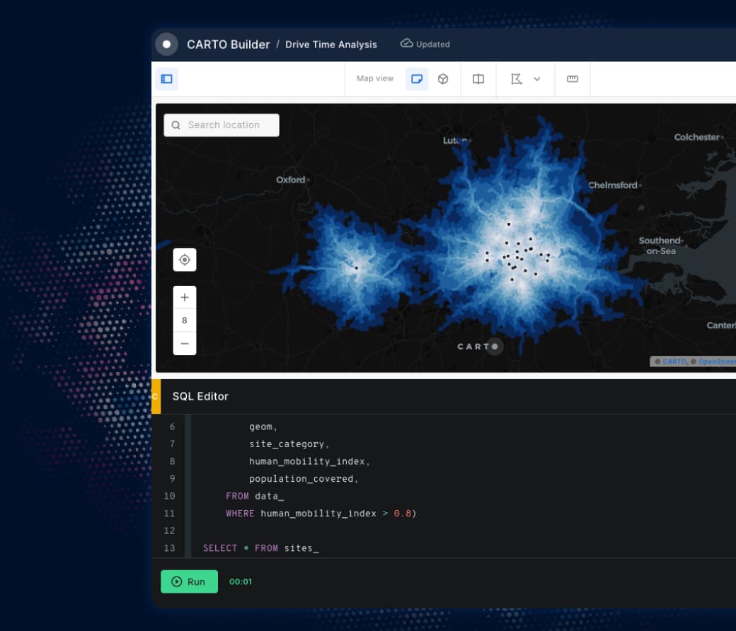
CARTO Builder
Generate rich data insights natively in your cloud data warehouse. Accelerate decision-making and share your analysis results with ease.

Trusted by the world's leading geospatial analysts


Run natively on your cloud data warehouse
Access your data instantly with a simple, intuitive interface, and start building your interactive maps running natively on top of the leading cloud data platforms.
Pick yours to learn more
Unmatched data visualization capabilities

Visualize your advanced spatial analytics at speed
Create and share dynamic dashboards to build engaging presentations and compelling reports - all from the same place. Builder includes an intuitive UI to add interactive widgets, SQL parameters, and filters to your maps.
Publish & share your insights
With Builder you can share your visualizations and dashboards in seconds; with other users in your organization, publicly on the web, or embedded in your applications. You have the control of your spatial analysis, whatever your use case.


Get inspired by our customers

“It is easy to use yet very powerful. Within a couple of hours, you can get a beautifully looking web map live. No need for coding or mapping knowledge as long as you understand your data. The advanced styling and analysis tools can get you even further.”

“I love its applicability. I have created numerous maps with CARTO Builder in the last year. For point features, you can use any icons imaginable and display all kinds of information in the pop-ups - without the hassle. I also created many heatmaps or progress maps that showed our team’s editing work in specific cities or regions.”

“For a digital mapping platform, CARTO Builder is both intuitive and efficient. It is comparatively the best platform I’ve used in the years I’ve been mapping, and they have been among the most helpful hands on assistance when it comes to snafus while working.”

Frequently asked questions
Our free 14-day trial gives you access to all CARTO components, including demo datasets and maps, and a CARTO Data Warehouse instance so you can fully evaluate the powerful features of our platform. If you are working on the cloud with large and complex datasets and using geospatial analysis for several use cases, we recommend you request a demo so you can start an assisted trial to make the most of our platform.
We designed the CARTO platform to handle datasets of all sizes with impressive performance, cost-effectively, on any modern device. Billions of points, polygons, and lines. Read here how we are making highly performant cloud-native maps.
No, CARTO also offers rich analytical capabilities, including Workflows, our low-code analysis design and automation tool, and the Analytics Toolbox, a set of functions and procedures you can use directly in your cloud data warehouse. We also offer CARTO for developers, a framework-agnostic approach to developing powerful spatial applications tailored to your needs.
Our enterprise-grade security, authentication, and data access controls let you publish and share your analysis securely with stakeholders. Create secure connections to your data warehouse, give access to your users with SSO, and share your interactive dashboards safely.
Related content


